AI Technology Brief
3D generation, depth estimation, matching, and Gaussian splats solve different construction problems
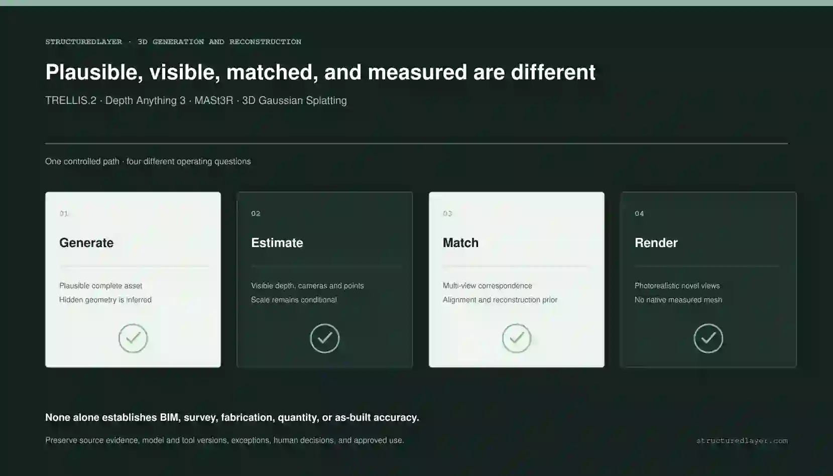
TRELLIS.2 generates plausible meshes, Depth Anything 3 estimates visible geometry, MASt3R supports multi-view matching, and 3D Gaussian Splatting renders novel views. None alone establishes BIM, survey, fabrication, quantity, or as-built accuracy.
01 / Independently verifiable claims
Begin with what the technology and standards actually support.
- TRELLIS.2 is a generative image-to-3D system that produces meshes and physically based material attributes. A single image leaves hidden surfaces and absolute scale unobserved, so the model must infer them.
- Depth Anything 3 supports monocular and multi-view depth, camera estimation, point maps, pose-conditioned operation, and related spatial representations. Its outputs are not automatically watertight, editable, or dimensionally validated meshes.
- MASt3R predicts 3D point maps and local descriptors for image matching, correspondence, localization, and reconstruction pipelines. Pairwise predictions still require alignment and can fail with poor overlap or difficult surfaces.
- 3D Gaussian Splatting represents scenes with optimized Gaussian primitives for high-quality novel-view rendering. The native representation is not a surface mesh and does not encode BIM elements, topology, dimensions, or construction semantics.
- TRELLIS.2 code and released 4B checkpoint are MIT, subject to separate dependency review. Depth Anything 3 code is Apache 2.0, but checkpoint licenses vary between Apache 2.0 and noncommercial CC BY-NC 4.0.
- MASt3R code and main checkpoints are noncommercial under CC BY-NC-SA 4.0 with additional training-dataset restrictions identified by the project.
- A photorealistic splat, plausible generated mesh, dense point map, or strong matching result does not establish survey, BIM, fabrication, structural, quantity, or as-built accuracy.
- Metric construction use needs known scale and independent validation through calibrated cameras, surveyed control, LiDAR, total-station or GNSS observations, known dimensions, or another approved measurement reference.
02 / The practical distinction
Generate, estimate, match, render, and measure answer different questions.
The methods can support one another, but the business must preserve which geometry was observed, estimated, aligned, generated, rendered, measured, and approved.
Generate
TRELLIS.2
Generates a visually complete mesh and materials from an image. Useful for assets and concepts; unseen geometry and scale are inferred rather than measured.
Estimate
Depth Anything 3
Estimates visible depth, cameras, point maps, and spatial consistency from one or more views. Model variant and supplied camera information affect scale behavior.
Match
MASt3R
Builds dense correspondence and point-map priors across overlapping images for matching, localization, alignment, and reconstruction workflows.
Render
3D Gaussian Splatting
Optimizes appearance primitives for novel views. It can look highly realistic while lacking native surface topology and dimensional authority.
Reconstruct
Conventional reconstruction
Uses calibrated capture, feature matching, bundle adjustment, multi-view stereo, fusion, meshing, and cleanup to reconstruct observed surfaces.
Validate
Measured construction record
Connects geometry to an approved coordinate frame, control observations, tolerances, error report, completeness, reviewer, and intended use.
03 / Operating architecture
A construction spatial pipeline should keep appearance, geometry, scale, and authority separate.
AI can accelerate initialization, completion, and visualization, while measurement control, reconstruction, validation, and approved downstream use remain explicit stages.
Input
Governed capture and control
Identify cameras, lenses, poses, calibration, overlap, lighting, movement, control points, known dimensions, LiDAR or survey references, and source rights.
Process
Method router
Select generation, depth, matching, Gaussian rendering, photogrammetry, LiDAR fusion, or a hybrid according to the required output and tolerance.
Evidence
Representation and provenance
Store source images, cameras, depth, points, splats, meshes, generated regions, scale transform, model versions, alignment, cleanup, and uncertainty.
Authority
Validation and approved use
Compare with withheld control, report error and completeness, label inferred geometry, and restrict downstream BIM, quantity, fabrication, or as-built use.
04 / Required records
The spatial output needs provenance for scale, cameras, transformations, and inferred geometry.
Capture session
Project, location, device, lens, calibration, images, poses, overlap, lighting, movement, operator, time, rights, and source hashes.
Control network
Coordinate system, control-point IDs, surveyed coordinates, known dimensions, accuracy, instrument, calibration, observer, and residuals.
Processing run
Method, code, checkpoint, license, dependencies, settings, hardware, input set, camera handling, random seed, runtime, and cost.
Spatial representation
Depth, point cloud, Gaussian set, mesh, texture, materials, units, scale, coordinate transform, confidence, and file version.
Inferred-region record
Occluded, generated, hole-filled, inpainted, smoothed, decimated, retopologized, or manually edited geometry and rationale.
Validation and release
Control comparison, absolute and relative error, completeness, limitations, reviewer, approved purpose, prohibited use, and superseded version.
05 / Construction example
An existing-condition communication model can combine methods without becoming a survey.
A property team may want a navigable visual record of a plant room or facade for planning and communication. The workflow can use learned geometry and Gaussian rendering while preserving where metric decisions require surveyed control.
Observe
Capture and control
Collect overlapping views with known camera handling and several independently measured control distances or surveyed points.
Recover
Estimate and match
Use Depth Anything 3 or MASt3R as priors for cameras, depth, correspondence, and dense initialization; refine with geometric methods.
Communicate
Render and complete
Use Gaussian splats for visual navigation and TRELLIS.2 only for clearly labeled decorative or unobserved asset regions where plausibility is acceptable.
Control
Validate and restrict
Report control error and completeness; prevent unvalidated geometry from quantities, fabrication, clash, setting-out, safety, or as-built acceptance.
06 / Deterministic controls
The method name cannot substitute for capture control and error reporting.
Known coordinate and scale
Anchor the result to approved control, known baselines, calibrated stereo, LiDAR, total station, GNSS, or verified dimensions where metric use is required.
Observed versus inferred label
Preserve which surfaces were directly observed, estimated from images, generated from priors, hole-filled, edited, or not captured.
Representation-specific use
Do not treat a depth map, point map, splat, mesh, textured asset, CAD object, BIM element, and survey deliverable as interchangeable.
License at checkpoint level
Record code, checkpoint, model card, training-data restrictions, dependency terms, input rights, and generated-output terms for the exact version.
Withheld validation
Compare against control not used to align or tune the output and report error by distance, surface, viewpoint, material, and location.
Human release boundary
Require qualified survey, design, engineering, BIM, fabrication, quantity, safety, or asset-information review for consequential use.
07 / Failure analysis
Visual realism can hide dimensional, topological, and evidential failure.
The generated backside looks convincing
A single image did not observe it. Openings, thickness, symmetry, connectors, labels, underside, and internal geometry may be invented.
Depth appears smooth but scale is wrong
Unknown focal length, crop, digital zoom, lens distortion, learned priors, or absent control can bias absolute dimensions.
Multi-view alignment drifts
Weak overlap, repeated facade patterns, textureless walls, reflections, moving objects, and loop errors can deform a larger reconstruction.
The Gaussian view is photorealistic
Floaters and view-dependent appearance can conceal weak geometry; the representation has no native planes, walls, edges, object semantics, or watertight surface.
Mesh cleanup removes evidence
Smoothing, decimation, hole filling, retopology, snapping, and manual editing can improve presentation while changing observed geometry.
The selected checkpoint cannot be used commercially
Project code may be permissive while a larger checkpoint, training dataset, dependency, or related model remains noncommercial or separately restricted.
08 / Deployment and cost
Select the least authoritative output that still serves the business purpose.
Plausible
Concept asset
Use TRELLIS.2 or another generative model for reviewed visualization assets where plausible completion is acceptable and measured identity is not implied.
Estimated
Spatial understanding
Use Depth Anything 3 or MASt3R-derived priors for visible depth, cameras, matching, retrieval, coarse context, and reconstruction initialization.
Communicative
Visual digital record
Use Gaussian rendering or hybrid reconstruction for navigable appearance with source capture, control, limitations, and a clear non-survey boundary.
Measured
Metric deliverable
Use approved survey and reconstruction methods, calibrated capture, control, tolerances, QA, qualified review, and contractual deliverable standards.
- Capture planning, cameras, lenses, calibration, operators, access, overlap, lighting, control targets, LiDAR or survey observations
- GPU compute, model checkpoints, commercial permissions, dependencies, storage, transfer, image processing, and repeated runs
- Camera estimation, matching, bundle adjustment, depth fusion, Gaussian optimization, point-cloud processing, meshing, texturing, and cleanup
- Coordinate transforms, scale control, registration, withheld checks, error analysis, completeness assessment, and recapture
- BIM or CAD conversion, semantic modeling, object classification, manual correction, asset data, review, and downstream interoperability
- Documentation, provenance, versioning, model and license changes, qualified approval, delivery, archive, support, and replacement
09 / Evaluation
Construction evaluation should report geometric error and completeness, not only visual quality.
- Measure absolute distance and relative scale error against withheld control across near, far, planar, curved, thin, reflective, transparent, repetitive, and occluded surfaces.
- Report point-to-point, point-to-plane, plane flatness, normal, edge, opening-location, and known-dimension error where relevant to the intended use.
- Measure completeness by required surface area and identify missing, inferred, duplicated, floating, smoothed, or hole-filled regions.
- Repeat capture across devices, operators, lighting, viewpoints, image counts, overlap, and movement; report sensitivity and recapture requirements.
- Inspect topology, watertightness, manifold condition, UVs, textures, materials, units, coordinate frame, file compatibility, and editability separately.
- Run license and dependency checks for the exact code, checkpoint, weights, datasets, input media, output, and intended commercial distribution.
10 / Controlled pilot
Prove the operating boundary before expanding it.
Define the intended use
State whether the output is for concept, communication, navigation, planning, measurement, BIM, quantity, fabrication, or as-built use and define the tolerance.
Choose the representation
Select asset mesh, depth, points, cameras, splats, reconstructed mesh, CAD, or BIM according to downstream needs rather than visual novelty.
Capture with control
Plan overlap, calibration, movement, surfaces, access, known scale, surveyed control, rights, source identity, and withheld validation.
Run a hybrid comparison
Compare generation, depth, matching, Gaussian, and conventional reconstruction outputs on the same approved capture set.
Measure and disclose
Report error, completeness, inferred regions, failure surfaces, license boundary, processing edits, cost, and reviewer effort.
Release only for the proven purpose
Label the output and block more authoritative downstream use unless separate measurement, modeling, and qualified acceptance support it.
11 / StructuredLayer recommendation
Use TRELLIS.2 for plausible assets, Depth Anything 3 for learned visible geometry, MASt3R for multi-view correspondence, and Gaussian splats for appearance - but use measured control and qualified validation for construction geometry.
Begin with the downstream decision and tolerance. Preserve source images, cameras, scale references, model and checkpoint licenses, transformations, inferred regions, cleanup, and validation. A useful result may be a concept asset or navigable visual record. Do not relabel it as BIM, survey, fabrication, quantity, setting-out, clash, structural, or as-built evidence without the required measured pipeline and professional authority.
12 / Primary sources
Capability, governance, and implementation claims remain inspectable.
Microsoft
TRELLIS.2 official repository
Microsoft Research
TRELLIS.2 project page
ByteDance Seed
Depth Anything 3 official repository
ByteDance Seed
Depth Anything 3 API documentation
Depth Anything
Depth Anything 3 project page
NAVER
MASt3R official repository
arXiv
MASt3R paper
INRIA / arXiv
3D Gaussian Splatting paper
Stability AI
Stable Fast 3D official repository
Sources reviewed 25 July 2026. Technology capabilities, laws, guidance, terms, and pricing can change.
13 / Related StructuredLayer guidance
Continue from model selection into operating architecture.
Generated 3D Assets for Construction
Review generative models for conceptual communication with explicit non-BIM and non-measured boundaries.
Workflow Library
Review buyer-focused patterns for visual capture, project records, review, exceptions, and controlled outputs.
Specialist AI Agent Capabilities
Review controlled visual, 3D, drawing, document, fabrication, and parametric workflows.